Excerpt from a Bicycle Fantasy of WA State : Sort of a contunuation but also in some ways this might be considered a whole story in and of itself
Disclaimer: This is not the only story. There are many other possible stories; this is one, and, in time, more stories will leak from the seems.

Michael and I took a trip to our own home that lasted two and a half weeks in July. We began by buying some tickets on a train. This train was a “Cascade” train, going to and fro from the Cascades and back just like we’d like to do, so it was a good match for us. One of the only Amtrak lines on which you can just bring your bike and hang it on a rack in the luggage car as-is for the price of five dollars. I heard somewhere that they now have a new bullet train that takes you from Seattle to Portland and/or back at super-duper light speed (or something like that) but maybe I just heard what I wanted to. Who knows.
We got to Seattle with a startlingly small amount of information inscribed on our maps about the best way that we should go to get to our designated and determined highway target, the state hwy number 2 that crossed to the north and to the east of the big needle. But, with a little bit of assistance from some fellows, fellow cyclists on the bike-path that we did locate, we realized we were still on-the-mark and headed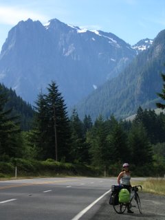 in the most correct direction. And. when the time came, so directed, we veered off the path and north of the sound, toward the snow-capped peaks to the east.
The next day we got up at a reasonable hour (whenever that was--we were living fine, timeless days off the train--right away, and answered only to the light). We went on over the pass and over 5,000ft (which meant that there was still a little bit of melting snow left, that far to the north), and down into the valleys of central Washington on the other side. We had planned on possibly staying off a gravel road on top, but, having gotten up there and being tired, we decided just to “drop” down the other side to an ostensibly-near campground somewhere further down the road. Unfortunately (at the time), though, the campground had been unceremoniously picked up and moved off to some other unidentified site somewhere not near at all. There was nothing there, instead. So we kept going, down and then up again some and down, to a random roadside pull-off “welcome center” which was especially welcoming to us since they had water and bathrooms and even a little old man with some “hello” lemonade. Then, down the road some more, was the town of Cole’s Corner, which consisted of exactly one gas station with beer and snacks and one espresso cart in the lot with frozen coffee drinks and at
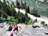 least one friendly inhabitant who could tell us about a lovely isolated spot near a river which rested not more than one mile away. This was a fabulous place, at which we camped for free and slurped up mac and cheese from a box bought at the itty bitty market.
The next leg of our trip began on the next day, when we rolled out of Cole’s Corner and headed toward Leavenworth, WA. We bought some terrific cashew brittle at some weird little establishment and soon arrived at our planned stop, Castle Rock, a rock wall situated in the canyon of the Wenatchee river.
 Here we climbed a pretty fun route called Midway Direct and took in some pretty good views too. Didn't meet but did cross paths and swap hi's with a cute little climbing guide taking out three burly guys and showing them who's boss. She smiled warmly when we passed by and then left a note saying “Have a Great Trip :)” with snickers bars and bananas on our bicycles at the bottom of the rock.
Energized and reinvigorated by this felicitous connection (not too mention its sugary rewards), by late afternoon we were rolling into Leavenworth, a bizarrely-themed “Bavarian” town with lots of waddling tourists shopping their way through sausage-hauses and all-year Christmas boutiques and stopping to gawk at locked-up mountain goats on a put-put course; they had been plucked from playing on the nearby peaks. Anyway, the place had plenty of groceries and German-ish beer and we found a place in the Snoqualmie-Mt. Baker National Forest to camp for free. This hidden-away place was a good find, and we stayed there off and on during our stay in Leavenworth, but we also took special measures to make sure that we weren’t behaving too conspicuously, to make sure the place would remain a good one to camp at later too.The sign at the beginning of town had said “Wilkommen en Leavenworth” so we felt somewhat greeted, at least.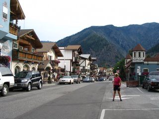
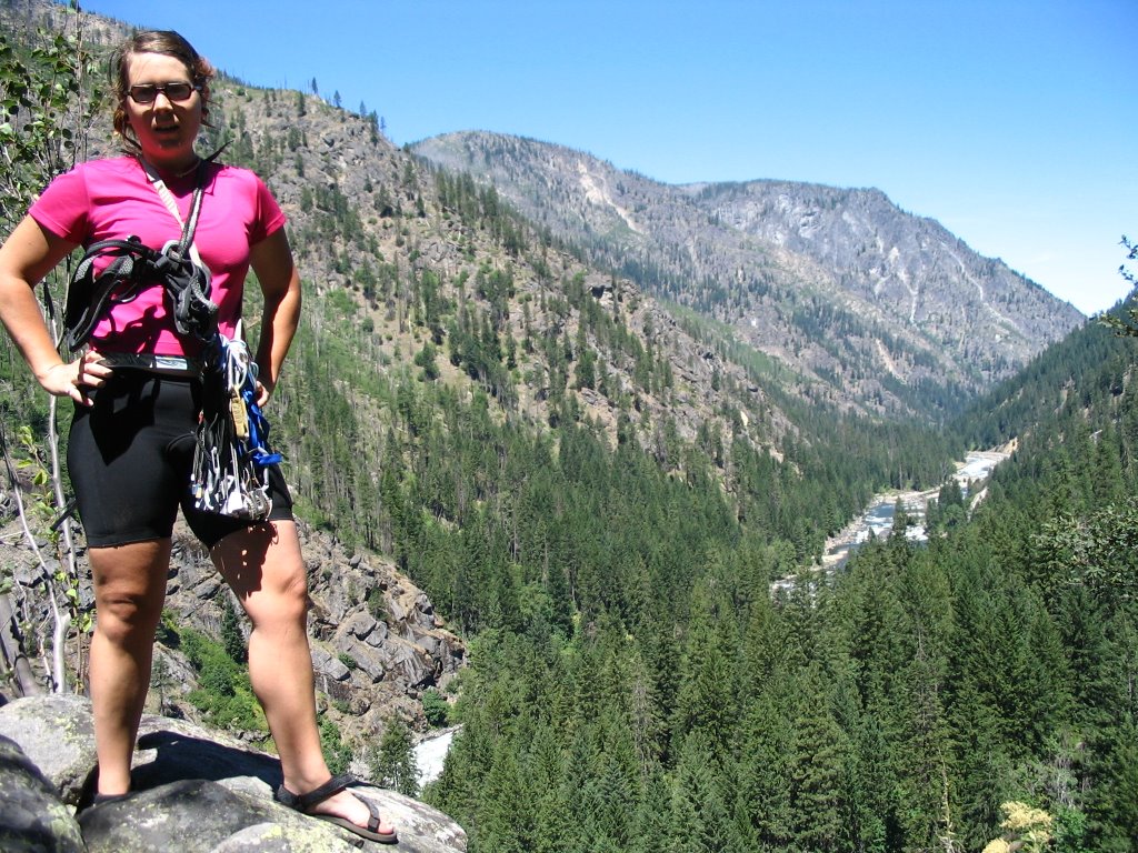
While we were in the Leavenworth area, we also traveled and stayed down the Icicle Canyon road in that region, along the canyon of the Icicle Creek, at some regulated park along that river. We climbed at several really fun areas while there in addition to attempting to take a picture to send in as an entry for a store in Portland’s photo contest with a 100-dollar prize. No word yet. At this point, I think some extra good photos are probably the most valuable product of our picture fun. We attempted to climb the route Orbit, up on a tall face called the Snow Creek Wall about a 2-hour-or-so hike up into the canyon, but it rained on us when we got there and we decided that, considering a possible rain-descent, going back was our best option. But at least we got to see some real wild white mountain goats and a truly beautiful place and it rained, serious and fierce, as we were getting back to the trailhead where our bikes were locked. And we proceeded to our nut-butter and jam sandwiches underneath the information and permit awning for a while when we got back.
The cragging along the side of the road in area was definitely and consistently of exceptional quality. So we worked on that (and I chewed contemplatively on my personal contributions to the failure of our Snow Creek Wall attempt, including what I increasingly realized was a fairly hefty amount of my own fear and anxiety about whether or not we would get to the top and if indeed it would be too hard for me and I would have to go down).
 It almost seems like there was something about a place like that, pretty remote once you get into it and poised in reality, just like a mountain standing in front on me, that I had come so far to climb, that a freeze-up was incited within me. My whole resolution froze up and backed off into itself, unable to overcome the pressure of it all. Of course, if you were to ask Michael, a marked lack of pressure arising from actual physical circumstances could even be the condition that characterized the ascent. It was easy for him. “If the 5. 9 pitch halfway up turns out to be too difficult, in any case, you can go around to the left and there is an easier variation.” But, psychologically, my mental and personal motivations became engaged in a refusal of the possibilities for variation. Inflexibility a downfall, seized my faculties, and I realized that I had become embroiled in the perceived pressures, in the grand scales, in all of the uncertainties associated with the unknown.

But at least cragging in the canyon gave me a really good chance to reflect on that, and, for better or worse, I became increasingly distracted by the enormous amount of private development and limitation to public access which had obviously been rampant in the time since our climbing manuals were printed. Everywhere we went, there were new homes built along the road to block and absorb the “beautiful and scenic vistas of the Icicle Canyon.” The beautiful private eyesores were lined up next to one another, bunched up between the river and the canyon walls, obstructing them from persons not invested in them primarily as property. I found this to be a deep violation of the fundamental rights of both us as climbers and as “public” shareholders in the welfare of the land and of the canyon itself to engage in that kind of “public” relationship to us, those that would inhabit and experience it. If it weren't for the signs. Or maybe we went anyway...
 After leaving the Leavenworth and Icicle Canyon areas, Michael, his bicycle, Bonnie Blue Bell and I all found ourselves heading in a trajectory that would take us off of hwy 2, onto Washington s.r. 97 and south with it across around 4,000 foot Blewett pass. Fruit. Lots and lots of roadside fruit. Here, again, we planned on there being the state park based on the map but that wasn’t, so we just kept going on. We watched as the land changed and changed itself, drastically, from the central semi-arid yet tree-lined mountains into a rolling golden desert filled with sagebrush and reptiles.
We found a much-needed hot shower and motel room in Ellensburg and ate out at a funny Mexican restaurant with drunk people yelling semi-jovially, half-antagonistically about Mexican restaurants. We moved on to our room and cable and turned off our heads for a while. The next day, we took a break and went 30 miles through the snaky Yakima River Canyon to Yakima, WA…quite a town, but I’m not really sure if it’s the kind you talk about per se…think minimarts and strip malls, seedy looking dives you think’ll be cheap but aren’t, then there was the randomly-placed brewery with excellent beer… a trademark of the Northwest. A fine choice of a town for another motel room, at least. Plenty of cheap ones; we swam in the teeny tiny swimming pool to our hearts’ content.
The next day, we took a side trip away from Yakima and went past Naches to a place called Teitan, WA, where there was a wildlife reserve, climbing on funky desert
basalt and at least one rattle snake with which Michael got up pretty close and personal inside a crack with his hand. But it wasn’t vicious; it didn’t bite. It was windy there, and we climbed a few routes before retiring to a nice little spot beside the Teitan River that was much enjoyed. And then back to Yakima, back to (a different, 2 dollars less) motel and rest up for our next day, through the Yakama Indian Reservation. I was excited to see the reservation, partially because I hadn’t had much experience being in one in the past, and partially because I the most convincing story I've been told about traditional Native American cultures and a history of European oppression. Of course, I knew that there was no historicized or "authentic" version of anything that I could expect to see evident in the Indian Reservation from a rode-side view today.
This turned out to be the most arid, deserted, hot, unforgiving land that I had ever personally encountered up to it. I missed the lush green mountainsides of Western Oregon and thought about how hard it would be for me to thrive in such circumstances if I had to try. The unseen specter of the Hanford Nuclear facility so close by us hung over me with its presence, adding an element of necessary caution, careful distance from silent dangers, to our time in the region. Finally, after having drunk our last drops of water in the late afternoon heat some time before, we reached the top of Satus Pass and descended toward the state park on its southern side, just out of the reservation. We drank lots of water and I had a cold shower and we thoroughly enjoyed the rest. We began to think of seeing the Columbia River Gorge the next day, of coming sometime to the end of our trip, of going home again. We th ought about not going home again. Of keeping on going. Down 97 to Oregon, to Madras, going to Smith Rock, on. But, as we approached Goldendale and the view of the wide deep Columbia, the heat burned hotter and we began to think of home affectionately again.
We wanted to keep going forever while we went, before the reality of going home seemed so tangible and present, but as it got closer, I think, we realized that we did want to go home sometime. We needed to be home soon, right now anyway. Just transitioning and dealing with being at home became an alluring incentive to continue our travels forever. But the weariness of that big world kicked our asses and sent us back, for now. For now, we keep on coming home. From Seattle, from Mt. Hood, from wherever we go.
But we weren’t there yet.
We got to Horsetheif Butte with enough provisions for two days. We climbed on it and remembered the time when we had come there in the spring. We swam in the cool river and rested our legs. Then we headed out again, bound for some place along the Wind River. We zoomed through the Gorge, on a route we had gone before, so we were comfortable with it. Soon into the day, though, the heat began to hit us both over the forehead like a wall we hadn't planned on. The papers said temperatures of up to 107 would make
 for records all over the region. The shade offered little relief. Our water bottles were filled often, and were often filled with very hot water. Michael began to devise an invention to insulate our bottles to be constructed when we got home. Again, we had our switches set on “just go,” so when we went down a wrong rode and couldn’t find a suitable place near the Wind River to camp, we just kept going. We bought groceries in Stevenson and, into the evening, we reached Beacon Rock State Park. It was up a steep windy road on the steep ridgeside above the river. The shade was abundant and soon we were feeling the cool watery breezes of the Pacific Northwest. Extreme relief.
Until the next day--another hot one--on which we sweatily climbed the 7-pitch route up Beacon Rock until afternoon and then hiked down and hit the pedals, bound for home, proper. North Portland. It was in our minds all afternoon, as we ascended and descended Cape Horn and coasted into Washougal and then navigated along interstate-like highways, cars merging and exiting constantly at high speeds, into downtown Vancouver, WA. Then we made our final symbolic leap home before the real thing: across the I-5 bridge and out of Washington, into Portland and Oregon. Home. After taking a train to what seemed to us cyclists like a suddenly far-off place. What Sound? It was Washington, but it ended up, all, to be on our way home. A detour. A tour. I started my new job the week I got back. I start an internship with a magazine soon. Michael put his stuff down, then picked it back up and biked to Mt. St. Helens to climb it in two days and he came back already. School in September. I’m glad to be home. I’m thinking about how I will leave and be gone again, and so how I’ll come back again soon.

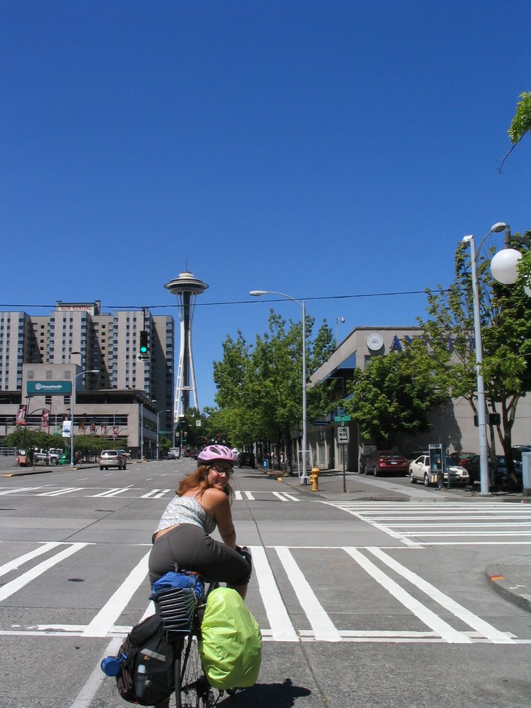
We got to Seattle with a startlingly small amount of information inscribed on our maps about the best way that we should go to get to our designated and determined highway target, the state hwy number 2 that crossed to the north and to the east of the big needle. But, with a little bit of assistance from some fellows, fellow cyclists on the bike-path that we did locate, we realized we were still on-the-mark and headed
 in the most correct direction. And. when the time came, so directed, we veered off the path and north of the sound, toward the snow-capped peaks to the east.
Our first night on the road, I stabled Bonnie Blue Bell up to a decent enough picnic table sitting in the middle of a state park called Wallace Falls about 30 miles before Stevens Pass, near Gold Bar, on highway 2. There were parking spaces a-plenty with walk-in only camping, which would have spelled an expensive night for us, except that Washington apparently has a general rule that all hiker-biker camping in parks is 10 dollars/1 tent. (Which isn’t exactly cheap compared with hwy 101’s famous 2 and 4-dollar spots, but it’s better than being asked to pay 16 or more, at least). We met a strange campyard guard-dog type character lurking there who wanted to talk talk talk about his lobotomy past and his nuclear test-site rattled future.
The next day we got up at a reasonable hour (whenever that was--we were living fine, timeless days off the train--right away, and answered only to the light). We went on over the pass and over 5,000ft (which meant that there was still a little bit of melting snow left, that far to the north), and down into the valleys of central Washington on the other side.
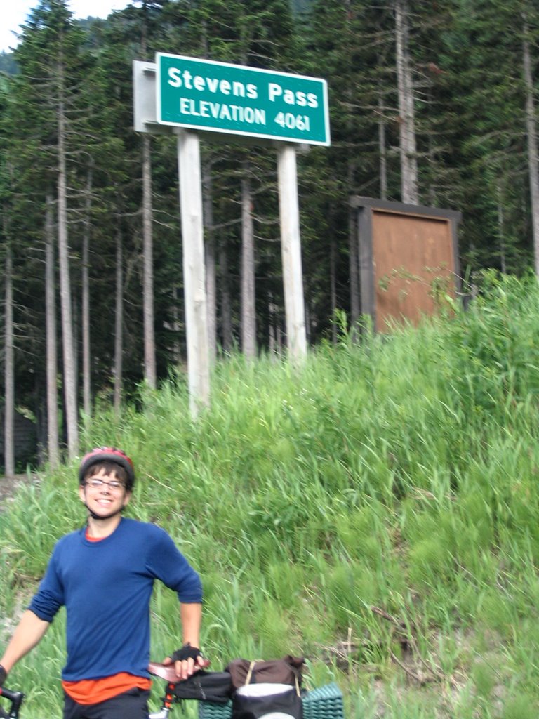 We had planned on possibly staying off a gravel road on top, but, having gotten up there and being tired, we decided just to “drop” down the other side to an ostensibly-near campground somewhere further down the road. Unfortunately (at the time), though, the campground had been unceremoniously picked up and moved off to some other unidentified site somewhere not near at all. There was nothing there, instead. So we kept going, down and then up again some and down, to a random roadside pull-off “welcome center” which was especially welcoming to us since they had water and bathrooms and even a little old man with some “hello” lemonade. Then, down the road some more, was the town of Cole’s Corner, which consisted of exactly one gas station with beer and snacks and one espresso cart in the lot with frozen coffee drinks and at
 least one friendly inhabitant who could tell us about a lovely isolated spot near a river which rested not more than one mile away. This was a fabulous place, at which we camped for free and slurped up mac and cheese from a box bought at the itty bitty market.
The next leg of our trip began on the next day, when we rolled out of Cole’s Corner and headed toward Leavenworth, WA. We bought some terrific cashew brittle at some weird little establishment and soon arrived at our planned stop, Castle Rock, a rock wall situated in the canyon of the Wenatchee river.
 Here we climbed a pretty fun route called Midway Direct and took in some pretty good views too. Didn't meet but did cross paths and swap hi's with a cute little climbing guide taking out three burly guys and showing them who's boss. She smiled warmly when we passed by and then left a note saying “Have a Great Trip :)” with snickers bars and bananas on our bicycles at the bottom of the rock.
Energized and reinvigorated by this felicitous connection (not too mention its sugary rewards), by late afternoon we were rolling into Leavenworth, a bizarrely-themed “Bavarian” town with lots of waddling tourists shopping their way through sausage-hauses and all-year Christmas boutiques and stopping to gawk at locked-up mountain goats on a put-put course; they had been plucked from playing on the nearby peaks. Anyway, the place had plenty of groceries and German-ish beer and we found a place in the Snoqualmie-Mt. Baker National Forest to camp for free. This hidden-away place was a good find, and we stayed there off and on during our stay in Leavenworth, but we also took special measures to make sure that we weren’t behaving too conspicuously, to make sure the place would remain a good one to camp at later too.The sign at the beginning of town had said “Wilkommen en Leavenworth” so we felt somewhat greeted, at least.

While we were in the Leavenworth area, we also traveled and stayed down the Icicle Canyon road in that region, along the canyon of the Icicle Creek, at some regulated park along that river. We climbed at several really fun areas while there in addition to attempting to take a picture to send in as an entry for a store in Portland’s photo contest with a 100-dollar prize. No word yet. At this point, I think some extra good photos are probably the most valuable product of our picture fun. We attempted to climb the route Orbit, up on a tall face called the Snow Creek Wall about a 2-hour-or-so hike up into the canyon, but it rained on us when we got there and we decided that, considering a possible rain-descent, going back was our best option. But at least we got to see some real wild white mountain goats and a truly beautiful place and it rained, serious and fierce, as we were getting back to the trailhead where our bikes were locked. And we proceeded to our nut-butter and jam sandwiches underneath the information and permit awning for a while when we got back.
The cragging along the side of the road in area was definitely and consistently of exceptional quality. So we worked on that (and I chewed contemplatively on my personal contributions to the failure of our Snow Creek Wall attempt, including what I increasingly realized was a fairly hefty amount of my own fear and anxiety about whether or not we would get to the top and if indeed it would be too hard for me and I would have to go down).
 It almost seems like there was something about a place like that, pretty remote once you get into it and poised in reality, just like a mountain standing in front on me, that I had come so far to climb, that a freeze-up was incited within me. My whole resolution froze up and backed off into itself, unable to overcome the pressure of it all. Of course, if you were to ask Michael, a marked lack of pressure arising from actual physical circumstances could even be the condition that characterized the ascent. It was easy for him. “If the 5. 9 pitch halfway up turns out to be too difficult, in any case, you can go around to the left and there is an easier variation.” But, psychologically, my mental and personal motivations became engaged in a refusal of the possibilities for variation. Inflexibility a downfall, seized my faculties, and I realized that I had become embroiled in the perceived pressures, in the grand scales, in all of the uncertainties associated with the unknown.
But at least cragging in the canyon gave me a really good chance to reflect on that, and, for better or worse, I became increasingly distracted by the enormous amount of private development and limitation to public access which had obviously been rampant in the time since our climbing manuals were printed. Everywhere we went, there were new homes built along the road to block and absorb the “beautiful and scenic vistas of the Icicle Canyon.” The beautiful private eyesores
 were lined up next to one another, bunched up between the river and the canyon walls, obstructing them from persons not invested in them primarily as property. I found this to be a deep violation of the fundamental rights of both us as climbers and as “public” shareholders in the welfare of the land and of the canyon itself to engage in that kind of “public” relationship to us, those that would inhabit and experience it. If it weren't for the signs. Or maybe we went anyway...
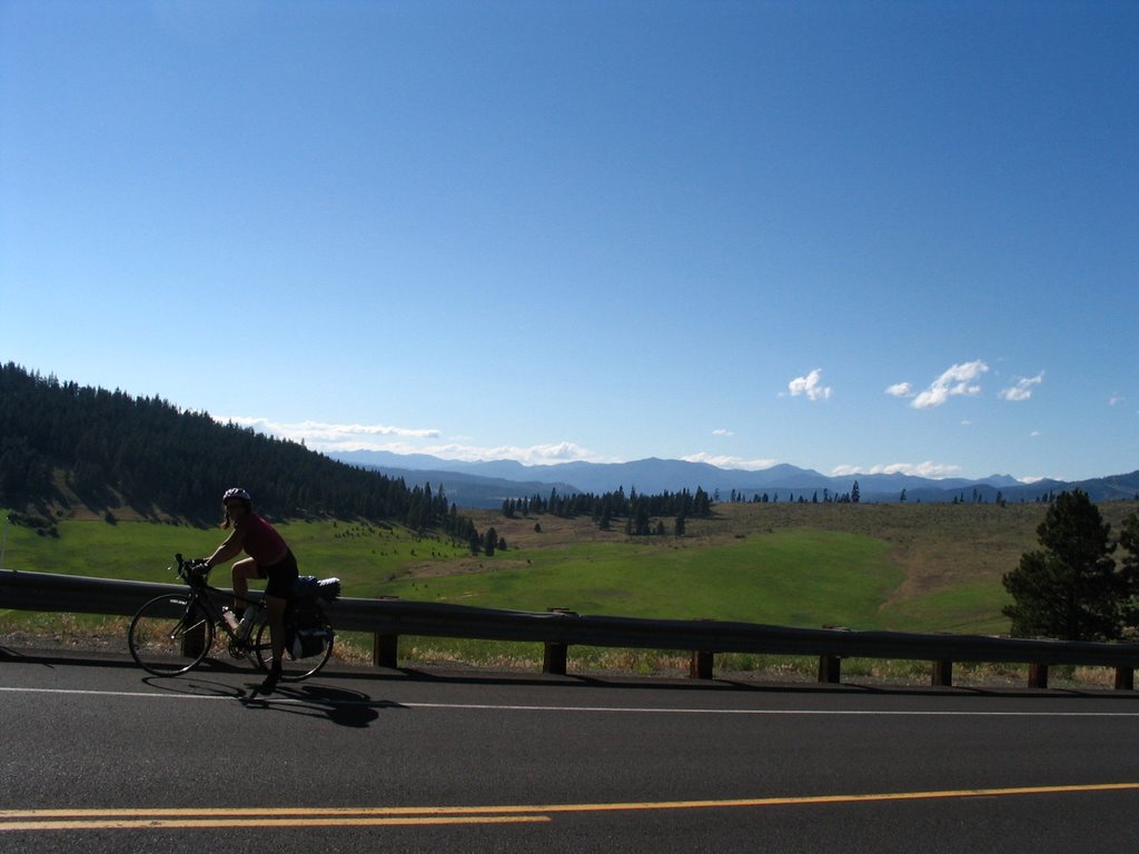 After leaving the Leavenworth and Icicle Canyon areas, Michael, his bicycle, Bonnie Blue Bell and I all found ourselves heading in a trajectory that would take us off of hwy 2, onto Washington s.r. 97 and south with it across around 4,000 foot Blewett pass. Fruit. Lots and lots of roadside fruit. Here, again, we planned on there being the state park based on the map but that wasn’t, so we just kept going on. We watched as the land changed and changed itself, drastically, from the central semi-arid yet tree-lined mountains into a rolling golden desert filled with sagebrush and reptiles.
We found a much-needed hot shower and motel room in Ellensburg and ate out at a funny Mexican restaurant with drunk people yelling semi-jovially,
 half-antagonistically about Mexican restaurants. We moved on to our room and cable and turned off our heads for a while. The next day, we took a break and went 30 miles through the snaky Yakima River Canyon to Yakima, WA…quite a town, but I’m not really sure if it’s the kind you talk about per se…think minimarts and strip malls, seedy looking dives you think’ll be cheap but aren’t, then there was the randomly-placed brewery with excellent beer… a trademark of the Northwest. A fine choice of a town for another motel room, at least. Plenty of cheap ones; we swam in the teeny tiny swimming pool to our hearts’ content.
The next day, we took a side trip away from Yakima and went past Naches to a place called Teitan, WA, where there was a wildlife reserve, climbing on funky desert

basalt and at least one rattle snake with which Michael got up pretty close and personal inside a crack with his hand. But it wasn’t vicious; it didn’t bite. It was windy there, and we climbed a few routes before retiring to a nice little spot beside the Teitan River that was much enjoyed. And then back to Yakima, back to (a different, 2 dollars less) motel and rest up for our next day, through the Yakama Indian Reservation. I was excited to see the reservation, partially because I hadn’t had much experience being in one in the past, and partially because I the most convincing story I've been told about traditional Native American cultures and a history of European oppression. Of course, I knew that there was no historicized or "authentic" version of anything that I could expect to see evident in the Indian Reservation from a rode-side view today.

This turned out to be the most arid, deserted, hot, unforgiving land that I had ever personally encountered up to it. I missed the lush green mountainsides of Western Oregon and thought about how hard it would be for me to thrive in such circumstances if I had to try. The unseen specter of the Hanford Nuclear facility so close by us hung over me with its presence, adding an element of necessary caution, careful distance from silent dangers, to our time in the region. Finally, after having drunk our last drops of water in the late afternoon heat some time before, we reached the top of Satus Pass and descended toward the state park on its southern side, just out of the reservation. We drank lots of water and I had a cold shower and we thoroughly enjoyed the rest. We began to think of seeing the Columbia River Gorge the next day, of coming sometime to the end of our trip, of going home again. We th
 ought about not going home again. Of keeping on going. Down 97 to Oregon, to Madras, going to Smith Rock, on. But, as we approached Goldendale and the view of the wide deep Columbia, the heat burned hotter and we began to think of home affectionately again.
We wanted to keep going forever while we went, before the reality of going home seemed so tangible and present, but as it got closer, I think, we realized that we did want to go home sometime. We needed to be home soon, right now anyway. Just transitioning and dealing with being at home became an alluring incentive to continue our travels forever. But the weariness of that big world kicked our asses and sent us back, for now. For now, we keep on coming home. From Seattle, from Mt. Hood, from wherever we go.
But
 we weren’t there yet.
We got
 to Horsetheif Butte with enough provisions for two days. We climbed on it and remembered the time when we had come there in the spring. We swam in the cool river and rested our legs. Then we headed out again, bound for some place along the Wind River. We zoomed through the Gorge, on a route we had gone before, so we were comfortable with it. Soon into the day, though, the heat began to hit us both over the forehead like a wall we hadn't planned on. The papers said temperatures of up to 107 would make
 for records all over the region. The shade offered little relief. Our water bottles were filled often, and were often filled with very hot water. Michael began to devise an invention to insulate our bottles to be constructed when we got home. Again, we had our switches set on “just go,” so when we went down a wrong rode and couldn’t find a suitable place near the Wind River to camp, we just kept going. We bought groceries in Stevenson and, into the evening, we reached Beacon Rock State Park. It was up a steep windy road on the steep ridgeside above the river. The shade was abundant and soon we were feeling the cool watery breezes of the Pacific Northwest. Extreme relief.
Until the next day--another hot one--on which we sweatily climbed the 7-pitch route up Beacon Rock until afternoon and then hiked down and hit the pedals, bound for home, proper. North Portland. It was in our minds all afternoon, as we ascended and descended Cape Horn and coasted into Washougal and then navigated along interstate-like highways, cars merging and exiting constantly at high speeds, into downtown Vancouver, WA. Then we made our final symbolic leap home before the real thing: across the I-5 bridge and out of Washington, into Portland and Oregon. Home. After taking a train to what seemed to us cyclists like a suddenly far-off place. What Sound? It was Washington, but it ended up, all, to be on our way home. A detour. A tour. I started my new job the week I got back. I start an internship with a magazine soon. Michael put his stuff down, then picked it back up and biked to Mt. St. Helens to climb it in two days and he came back already. School in September. I’m glad to be home. I’m thinking about how I will leave and be gone again, and so how I’ll come back again soon.

posted by Rachael at
8/02/2006 04:26:00 PM
![]()
![]()

